Boating USA app for iPhone and iPad
THIS APP WILL BE DISCONTINUED!
> SEARCH this store for our “Boating Marine & Lakes” FREE app.
> Download it and get a 2-week trial of the subscription to check out the charts and features. Then subscribe.
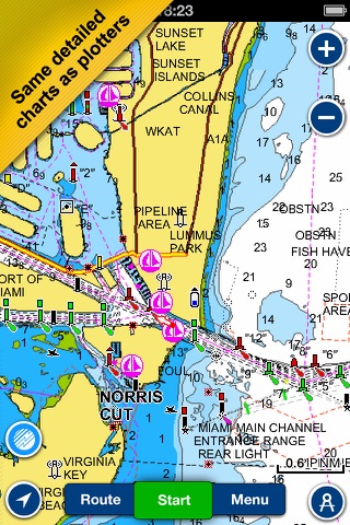
Boating Marine & Lakes is a favorite among cruisers, anglers, sailors, and divers, with the same detailed charts and advanced features as on the best GPS plotters.
With Boating Marine & Lakes you will get:
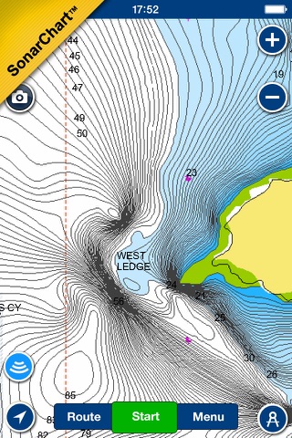
>THE MOST DETAILED CHART LAYERS FOR OFFLINE USE - Nautical Chart, SonarChart™ and Community Edits. Plus, local information from the Garmin ActiveCaptain Community.
> DAILY CHART UPDATES, more than 2,000 every day!
> ADVANCED FEATURES like Dock-to-dock Autorouting, Advanced Map Options and more!
Search for "Boating Marine & Lakes” and discover more.
Pros and cons of Boating USA app for iPhone and iPad
Boating USA app good for
excellent standalone app. I tried memory map and gave up after 2hrs. Navionics was intuitive and well laid out. I had to navigate the Fort Myers Sanibel bays and despite it being my first time in those waters the program allowed me to easily locate and navigate right through the ICWS into the bay and back . Map quality was great, interface was good. Plotted a track well and the tide feature helpful when guessing the depth of shoals. Well worth the money. Memory map required me to download maps via PC, this program was truly stand alone.
Honestly if your a fisherman just spend the 10 dollars and you wont regret it one bit! Not kidding either. I love this app and use it all the time
I use this app all the time when I visit Charleston. Simple and easy for anyone to use. I highly recommend trying it
I love this app. I use it for ice fishing and camping a lot. I wish there was a better system for sorting and selecting which waypoints you want displayed on the map. Other than that this is a 10/5 star app!
Cant say enough good things about this app. I boat a lot and always have this app running while I boat. Saved me from running into shallow water. I love looking at the saved tracks and reviewing my trips. Top speed, total distance traveled, ect. Works even where you dont have cell coverage. Just make sure you download the maps a head of time. I am part of an old boat club and recommend this app to everyone. I am amazed by this app every time I use it.
This gives me exactly what I need for fishing. Contours of lakes. And I couldnt believe how many tiny lakes on this app have contour data. Its extremely accurate. I ice fish and this saves me from having to drill tons of holes to find the depths And drop offs to fish. Also its great to be able to download areas so that I dont need cellular coverage to use the maps. Well worth the 10 bucks. Thanks!!!
Some bad moments
This app is seriously messed up. The map contours never fit the outline of the lake and it constantly moves all over the place. It shows Im going up to 2mph when Im laying in my bed looking at it. I have a paid subscription and expect a working app!! Please fix asap!!!
The app works great for its intended purpose but it has a flaw that ruins it. For some reason they placed a very light colored link that easily blends into the background to something called openstreet. It is placed right in the middle lower section so almost every time you try to scroll your map, the link will get activated and it takes you to this website and away from your map. It is very worrisome if you are tracking your way points through a tough channel and suddenly your map is gone. I have the paid version of navionics too. If they could get rid of that stupid link it could be a great app.
the new update is super dumb, why is it black and it just went down the toilet
Gave it sea trials tonight. When I exited the program it popped up a screen asking about running in background. Neither option worked - Continue or Setting. It did hang the phone. Had to sync with my laptop and remove it. Reinstalled it and same screen again. Removed it again and wont reinstall. High risk application.
The lake maps dont have depths or contours on them. There is cheaper or even free apps available that are a lot more detailed. This is the first review I have ever written but this needed said.
this is not worth downloading if it was free. there are several others available that are free or lower priced that give you must more detail and information on lakes and waterways. i am really sorry i downloaded this, i hope to review will aid others in not making the same mistake.
Usually Boating USA iOS app used & searched for
tide chart,
tides 4 fishing,
tide charts,
fishing charts,
tides for fishing,
fishing maps,
fishing map,
gps navigation,
fishing gps,
lake navigation,
lake gps,
Boating USA,
fishing tides,
navionics boating usa,
boating usa hd,
boating usa gps nautical chart,
boating usa - gps map navigator,
boating usa hd nautical charts,
boating usa hd - gps map navigator,
and other. So, download free Boating USA .ipa to run this nice iOS application on iPhone and iPad.